Ocean Floor Contour Mapping
Intro
Scientists know more about the surface of the moon than about the bottom of the ocean. The broad size of the ocean floor, its depth and its combination of extreme conditions (cold, dark, with intense water pressure) all contribute to making its exploration difficult. Early civilizations believed the ocean floor to be a smooth bowl, devoid of features or life. However, the ocean floor is not flat; it has a wide variety of geological features (e.g., Table 7.6).
Navigators of ships and submarines are interested in avoiding dangers or impediments to their progress. Marine archeologists and professional treasure hunters are interested in finding areas likely to have shipwrecks. Geologists and oceanographers are interested in what the seafloor can tell them about the recent and ancient history of the planet, the formation of islands and ridges, and the movement of geologic plates. Biologists, conservationists, economists, and fishermen are interested in features that support large populations of marine life. Oceanographers, geographers, mariners, and cartographers have a whole vocabulary for these features. Table 7.6 lists many of the common features of the seafloor and coastline.
Navigators of ships and submarines are interested in avoiding dangers or impediments to their progress. Marine archeologists and professional treasure hunters are interested in finding areas likely to have shipwrecks. Geologists and oceanographers are interested in what the seafloor can tell them about the recent and ancient history of the planet, the formation of islands and ridges, and the movement of geologic plates. Biologists, conservationists, economists, and fishermen are interested in features that support large populations of marine life. Oceanographers, geographers, mariners, and cartographers have a whole vocabulary for these features. Table 7.6 lists many of the common features of the seafloor and coastline.
Table 7.6
Abyssal plain. A flat region of deep ocean basins.
Alluvial fan. A broad, sloping deposit of sediments at the mouth of a river or at the foot of a submarine canyon or a river canyon.
Atoll. A ring-shaped coral reef surrounding a lagoon. It may have low sand islands. Atolls rest on submerged volcanic islands.
Bank. A navigable shallow area of the ocean caused either by elevation of the seafloor or by submergence of a landmass.
Bay. An inlet of the sea; an indentation in the shoreline, often between headlands or capes.
Cape. A large point or extension of land jutting into a body of water. A cape may be a peninsula or a hook of land.
Channel. A deeper part of a river or harbor that is navigable. The word is sometimes used to name a broad strait.
Cliff. A very steep or overhanging land feature.
Coast. A strip of land bordering the sea.
Continental shelf. The land forming the shallow seafloor extending outward from the edge of a continent; submerged part of a continent extending outward 15 km to 50 km to the continental slope.
Continental slope. The sloping front of a continental shelf; the place where the continent ends. These are long slopes, often 20 km to 40 km wide or more. The bottom of the continental slope is the continental rise.
Continental rise. The area of the continental shelf between the continental slope and the deep seafloor where sediments from the continent accumulate.
Delta. An alluvial deposit at the mouth of a river.
Estuary. A river mouth or channel, or the drowned seaward end of a valley where fresh water from land mixes with seawater. River flow in some estuaries continues across the continental shelf, carving out a submarine canyon.
Guyot. A seamount with a flat top. Guyot tops are always below the ocean surface. Also called a tablemount.
Headland. A cape or other landform jutting into the ocean. It is usually high above water and prominent when viewed from the sea.
Island. A landmass smaller than a continent and surrounded by water.
Island chain. A group of islands formed by the same geological process (also called an archipelago).
Isthmus. A narrow strip of land connecting two larger landmasses.
Lagoon. A shallow body of quiet water almost completely cut off from the open ocean by coral reefs, barrier islands, or barrier beaches.
Ocean basin. A large depression in the earth's crust that holds the water of an ocean.
Ocean ridge. A long, continuous mountain range on the seafloor. Ocean ridges are often of volcanic origin at a point or line of separation in the earth's crust.
Ocean trench. A deep cut or trench in the seafloor, usually close to where continental shelves and seafloors meet.
Peninsula. A piece of land almost completely surrounded by water. It is usually connected to a larger land body by a narrow land strip called a neck or an isthmus.
Point. The narrow tip-end of a cape, headland, peninsula, or other land feature jutting into a body of water.
Reef. A shallow rock or coral formation often exposed at low tide. A fringing reef forms along the shore; a barrier reef is an offshore coral ridge.
Seamount. An isolated undersea hill or mountain. It is usually in the form of a cone.
Shoal. An area of the ocean, such as a sandbar, that is too shallow to navigate.
Sound. A wide waterway connecting two larger bodies of water. It may be a body of water between the mainland and an offshore island.
Strait. A long, narrow water passage connecting two larger bodies of water.
Contour Mapping
|
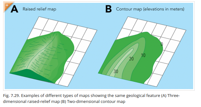
Scientists use detailed, accurate maps and models of geological features to help explain how the features of the earth form and how they change over time. Three-dimensional raised-relief maps provide a scale model of landforms and oceanic features (Fig. 7.29 A). Raised-relief maps or terrain models are sculpted maps that can be made to show the effects of tectonic activity or erosion, thus making the landforms look more realistic. Contour maps are two-dimensional maps that use colors and shades to convey information such as the relative depths and elevations of different geological features (Fig. 7.29 B). A contour map shows the depth (below sea level) or the elevation (above sea level) with a series of contour lines that follow a single representative depth or elevation. For example, sea level is recorded as “0” and represents the average low water level. Geographic features above sea level are recorded with positive numbers (such as 10 and 20, representing, for example, meters above sea level). Contour lines connect points on the map with the same elevation to help show changes in elevation. Contour maps for land are called topographic maps. Contour maps for ocean depths are called bathymetric maps or charts.
Procedure:
- Read the descriptions of features listed in Table 7.6.
- Refer to Table 7.6 as you identify features shown on the contour maps, Figs. (A) through Fig. (I)
- Examine each map to determine whether sea level, the zero (0) elevation contour line, is given. If it is, mark it with a colored pencil.
- Locate the contour lines of dry landform features—those with elevations above sea level. Using crayons or colored pencils, color-code the map to show differences in elevation. Save blue for seafloor contours.
- Locate the contour lines of features below sea level—those shown as negative numbers. Color-code the map in shades of blue to show differences in depth.
- Study the shapes of the contour lines, then identify and label features on the maps.
- What feature(s) were displayed on each of the contour maps?
- Were there any maps where it was difficult to identify the feature(s)? What additional information would you need to determine their identity?
- Form hypotheses to explain how each of the features in the contour maps formed. How might these features change over time?
- Think of an example of a place that fulfills the definition of more than one of the features in Table 7.6. Explain the reasoning for your choice.
- How are the following pairs alike and different?
- atoll and lagoon
- strait and sound
- isthmus and peninsula
- continental shelf and continental slope
- What is the importance of seafloor features to
- navigation?
- economics or society-building?
- archaeology?
- fisheries or other natural resources?
Figure A
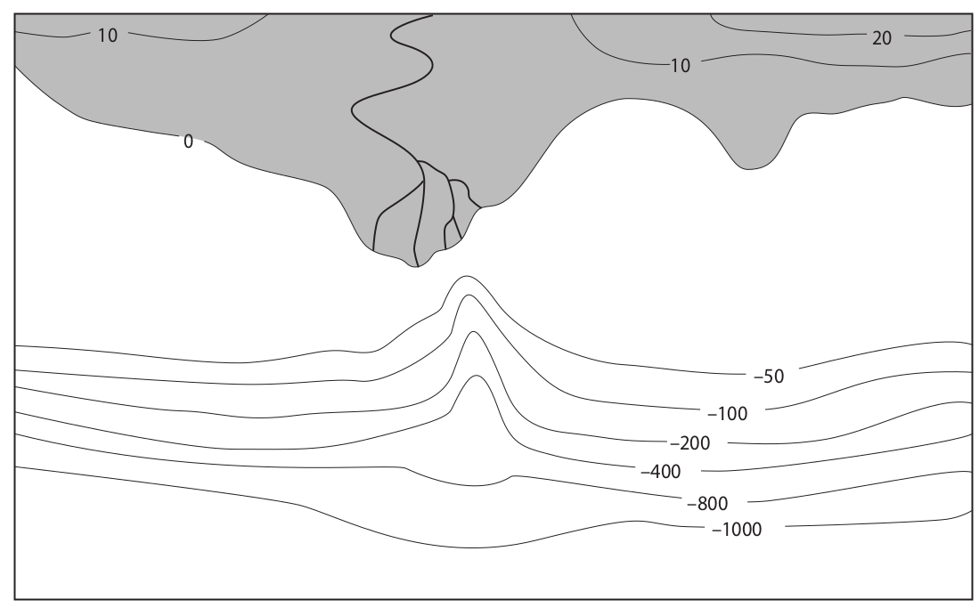
Figure B
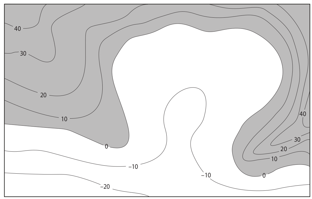
Figure C
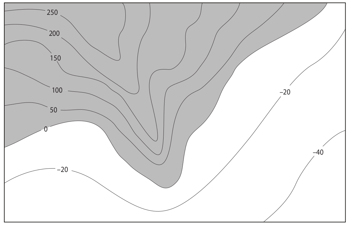
Figure D
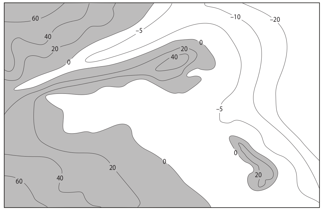
Figure E
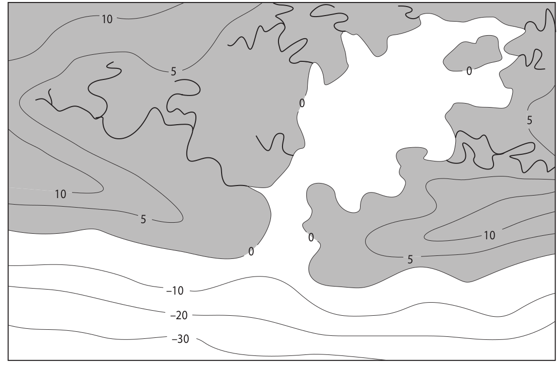
Figure F
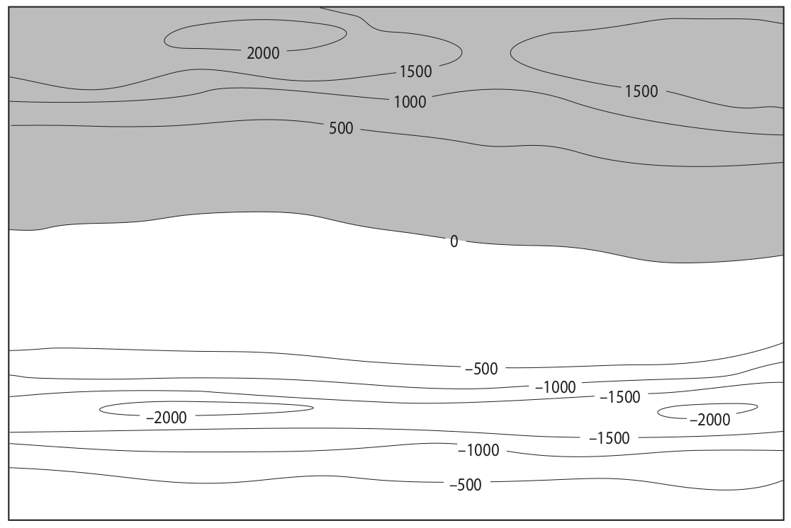
Figure G
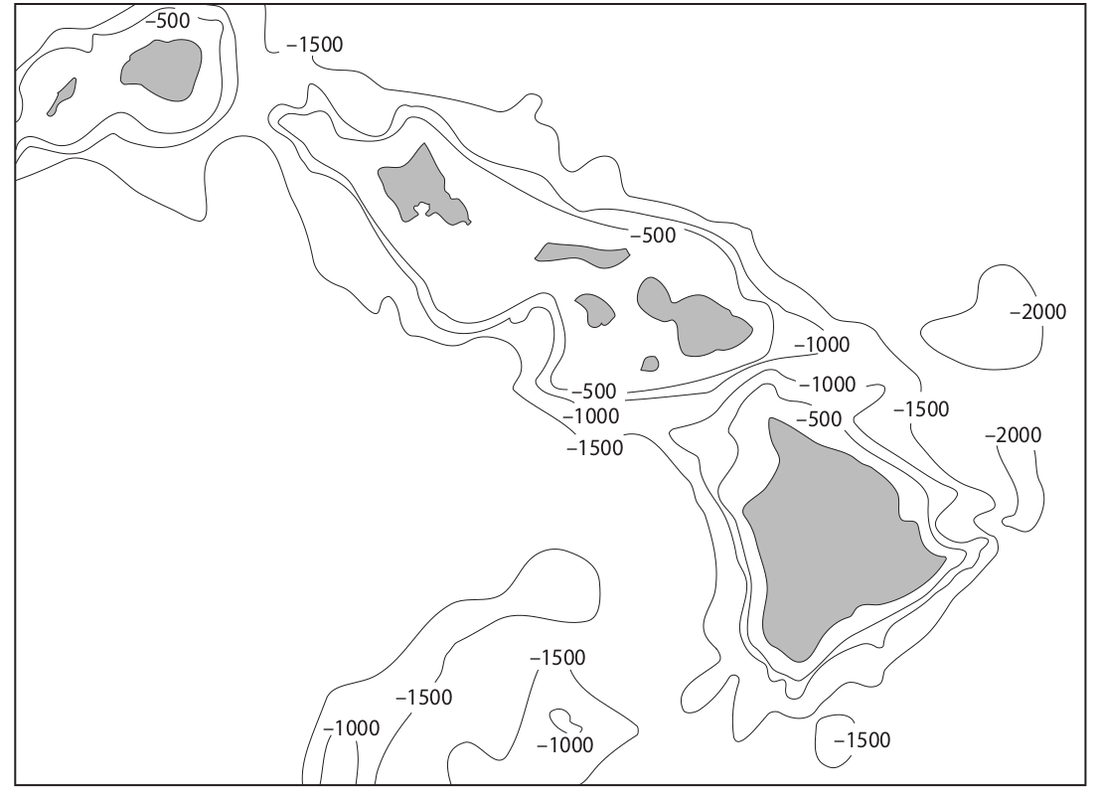
Figure H

Figure I

